
Weather Layers Explained
Understanding Weather Layers
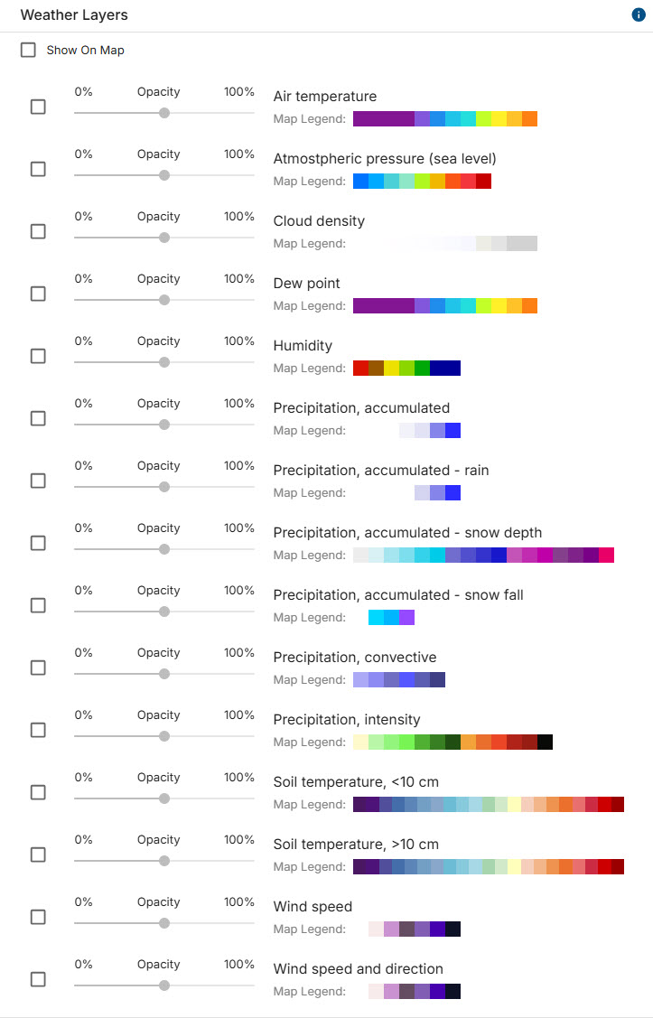
Turn layers on and off to get the weather conditions you need to operate your fleet safely and efficiently. Select to display the layers you want to view on the map. Watches and warnings are displayed by default
Current Weather Layers
Air Temperature
Easily spot areas where extreme heat or cold may affect operations. Identify when the temperature is optimum for specific types of installations.
Atmospheric Pressure
During tropical storm seasons, pinpoint the low-pressure areas that can indicate deteriorating weather conditions. Conversely, extremely high pressure in summer can cause extremely hot pavement and winds, while in winter it can bring sharp frosts that freeze road surfaces and cause icy patches.
Cloud Density
Dense clouds often accompany precipitation or high humidity, which can increase road surface moisture, creating slippery surfaces and reducing traction.
Dew Point
Dew point (the temperature at which air becomes saturated with water vapor) has a direct impact on road conditions, especially in winter and during foggy or damp weather.
When the air temperature drops to or below the dew point, water vapor can condense into liquid droplets. If the surface temperature is below freezing, these droplets can freeze, forming black ice. Dew point influences how quickly this happens — higher dew points mean more moisture in the air, so condensation and freezing can occur more readily even if the air temperature is only slightly below freezing. Roads can become icy before the air temperature hits freezing, especially on bridges and overpasses.
Humidity
High humidity affects road conditions primarily through creating surface moisture, which reduces traction. Additionally, some products may not adhere or cure well in high humidity.
Precipitation
This product offers 6 unique precipitation layers to better understand the current conditions and potential upcoming changes in road conditions.
- accumulated (all types)
- accumulated rain
- accumulated snow depth
- accumulated snowfall
- convective precipitation (where moisture may produce short-lived but intense rainfall)
- rainfall intensity
Soil Temperature
Soil temperature is displayed 2 ways based on soil depth. This information may be useful to our agricultural clients and those installing underground infrastructure.
- less than 10 cm/ 3.94 in
- deeper than 10 cm/ 3.94 in
Wind Speed / Wind Speed & Direction
The wind speed map gives you a visual of all winds more than ten mph, so customers can see where high or gusty winds may impact operations.
High wind speeds create strong lateral forces on vehicles, potentially pushing them out of their lane. Gusts, sudden changes in wind speed or direction, can cause abrupt shifts in aerodynamic forces, making it harder to maintain control.
High-profile vehicles are more affected because they present a larger surface area to the wind, while lighter vehicles and those with a high center of gravity are also more prone to sideslip or roll.
Forecast & Historical Weather Layers
This product includes two types of forecasts:
- Forecast for the next 6 hours for the US territory
- Forecast for the next 2 hours for other global area
- Historical weather map for the previous 2 days
- Update period: every 10 minutes
- Resolution: less than 1 km
- Global coverage
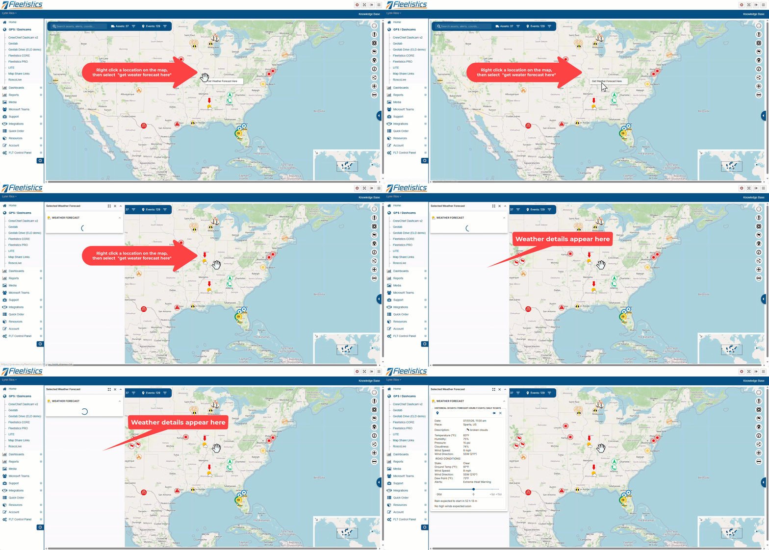
Right-click a location on the map to see the current weather for that location.
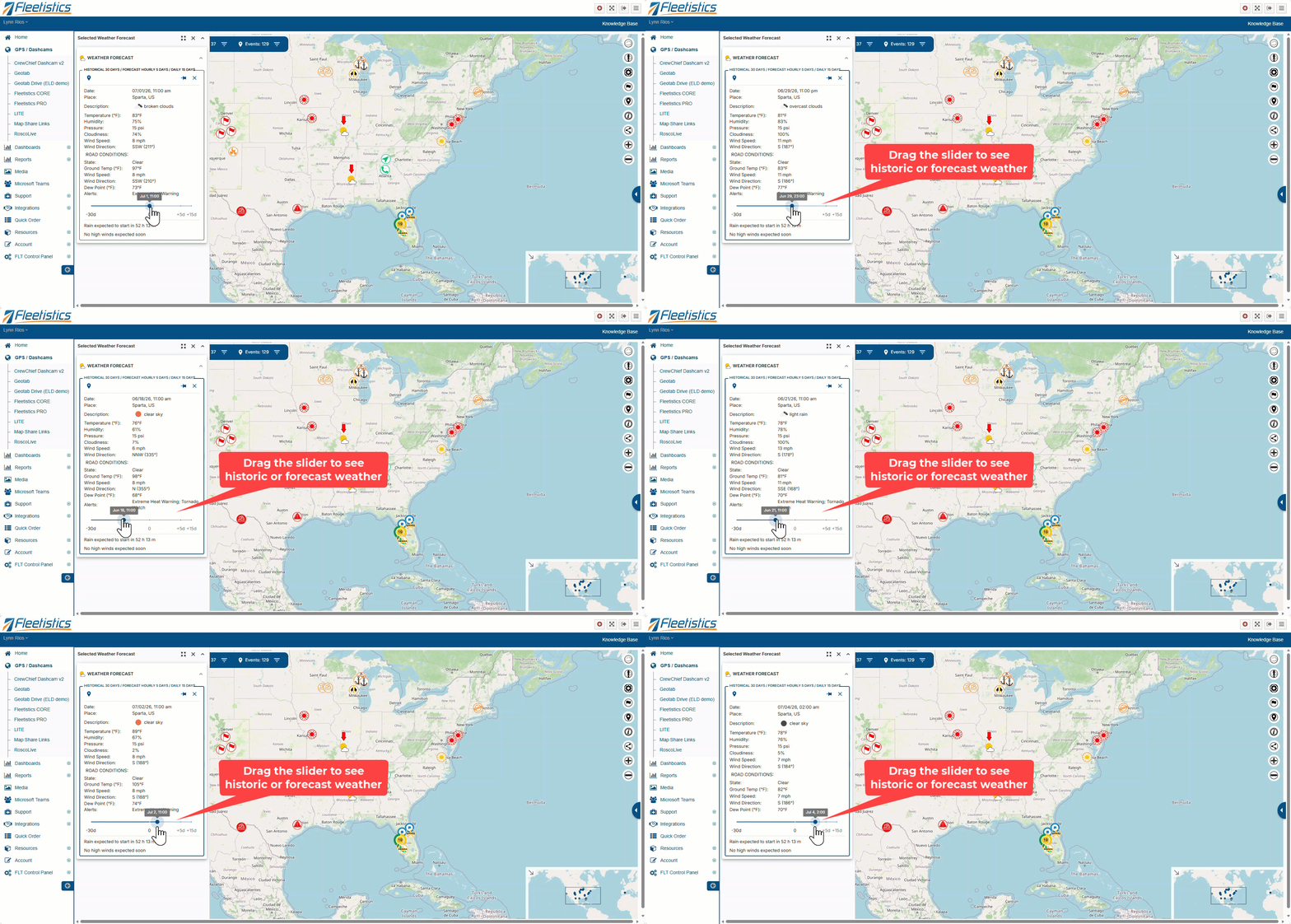
Use the slider to view historic and forecast weather.
Weather Definitions
Current Driver Weather
Fog (current weather): Visibility restriction affecting the sight-distance of a driver.
Heavy Fog (current weather): Urgent visibility restriction reducing visibility on the order of car lengths.
Light Rain: Rain that causes no visibility restriction but makes the road slippery.
Moderate Rain: Rain that causes some visibility restrictions.
Heavy Rain (current weather): Rapid rate of rain that is capable of quickly covering the roadway. Hydroplane possibilities increased.
Snow: Light to Moderate snow that may cause isolated travel problems.
Heavy Snow (current weather): Rapid rate of snowfall that quickly accumulates and reduces visibility. Travel problems are likely in these areas.
Ice: Freezing rain, sleet, or mixed wintry precipitation, capable of producing isolated travel problems.
Heavy Ice (current weather): Rapid rate of freezing rain, sleet, or mixed wintry precipitation, capable of quickly producing widespread travel problems and damage to trees and power lines.
Road Conditions
Snow (road condition): Snow in an amount covering (or just partially covering) secondary and less-travelled roads.
Heavy Snow (road condition): Snow in an amount covering major roadways and interstates
Patch Ice (road condition): Patchy ice, with bridges likely to experience issues and isolated patches of black ice.
Ice (road condition): Ice covered roads resulting in significant travel impacts.
Flood: Ponding on roads in areas and possible flash flooding.
Wet: Wet or damp roads, no ponding expected.
Threats/Hazards
Dangerous Wind: Crosswinds exceed 35mph, the critical threshold for high profile vehicles.
Hail: Based on Data’s patented storm tracking, highlights areas where Severe Hail is possible over the next fifteen minutes.
Twisting Wind: Based on Data’s patented storm tracking, highlights areas where Tornados are possible over the next fifteen minutes.